HikeHouse Eureka Springs is the place to start your hiking adventures
NOW AVAILABLE. Hike House Eureka Springs at 454 W Van Buren has opened its previously private trail to the general public.
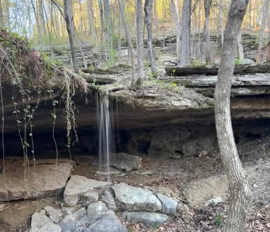
Sunken stream and Burnie Falls
This stream runs through the valley that cuts across Loblolly Pines Adventure Camp. Relax in a nearby hammock tree while listening to the trickling water. Great place for lunch or an afternoon nap. This is a private trail. Check in at the Hike House in Eureka Springs for permission and directions.
Check Hike House / Trail Hours Reserve Your Space
While at the Hike House –
Learn of other Eureka Springs trails
Black Bass Lake Spillway- accessible by foot
Accessed from Hwy 62 on Oil Springs Road in Eureka Springs, Black Bass Lake is home to an earthen and cut stone dam that dates to 1894 and is one of the oldest still standing in the Ozarks. Located just below town in the headwaters of the West Leatherwood Creek valley, visitors descend Oil Springs Road passing historic Oil and Johnson Springs. Spring rain makes the spillway a sparkling cascade but photos must be taken from the parking area because the spillway and dam are NO Access areas. General parking is available by the kiosk and across the bridge.
Shoreline Trail, Lake Leatherwood
Distance from Hike House to Trailhead – 3.4 miles
Dog Friendly w/ Leash
Follow the signs for Lake Leatherwood Marina and park in the parking area closest to the lake. Shoreline trail is closest to the water. The trail is 1.2 miles to the dam. To return, you can connect to Beacham Trail
Tea Kettle Falls in McIlroy-Madison Wildlife Management Area- 40 foot tall falls that exit from a spout-shaped rock ledge. Moderate trail-not well marked. 1 mile hike. Get trail guide for detailed instructions. Approximately 24 min drive to trailhead. Forest road access.
While at the Hike House –
Learn of other Arkansas Trails Near Eureka Springs
Sweden Falls
From All Trails .. Sweden Creek Falls is a 2.4 kilometer lightly trafficked out and back trail located near Kingston, Arkansas that features a waterfall and is good for all skill levels. The trail is primarily used for hiking, walking, and nature trips and is accessible year-round.
Glory Hole
From all trails.. Glory Hole Waterfall Trail is a 1.8 mile moderately trafficked out and back trail located near Deer, Arkansas that features a waterfall and is rated as moderate. The trail is primarily used for hiking and nature trips and is accessible year-round. Dogs are also able to use this trail but must be kept on leash.
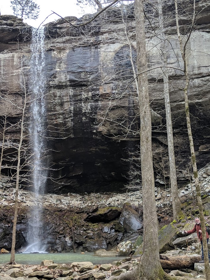
Hemmed in Hollow-accessible by foot or canoe
Hemmed in Hollow is the tallest waterfall between the Appalachians and Rockies and is located on the Buffalo River about an hour from Eureka Springs. Water falls from 220 feet and seldom quit flowing. The easiest way to access the falls is by canoe from the Buffalo River floating from Ponca to Kyles landing. About 70% of the way through this float is a nondescript landing on the left. Leave your canoe here and hike up stream. The trail is usually very clear and easy to follow. About 3/4 of a mile one way.
To hike to the falls, start at the trailhead located near Compton, AR and follow downhill to a streambed then turn left and hike up the stream bed to the falls. Getting back out will take much longer than getting there as the hike will be uphill.
Camp Orr-accessible by foot
Located just off of Hwy 74 near Mt. Sherman, between the Ponca intersection and Jasper. The turn off is to the north and is marked as “Kyle’s Landing” and BSA Camp Orr. This a a dirt road which which is three long, downhill miles. The BSA Camp Orr road is a hairpin corner off the Kyle’s Landing road, to the right. The falls are located down an easy, flat trail.
Hidden Cascades – accessible by canoe
Also on the Buffalo River found just down the river on the left side from the Hemmed in Hollow Falls, a piece of red material tied up to a tree that marks a trail leading to a small waterfall cascading from the rocks into the river. This path reveals many waterfalls tucked into the hillside.
Elise Falls at Smith Creek Preserve– 21-foot falls in slot along the bluff line accessed by 2-mile roundtrip moderate hike.